📍 Ventimiglia
🗓️ 2025-09-12
🌡️ 25 °C
🚙 138 km driven
The early bird was still very tired in the morning and didn’t really want to get up. But as we wanted to drive to our big vacation highlight and spend as much time there as possible, we got up and said hello to the dawning day.
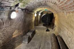
The LGKS (Ligurian Border Ridge Road) is an old military and border road in Liguria that runs along the border between France and Italy. It was originally built at the end of the 19th century to connect the many fortresses on the border ridge and to be able to move troops quickly. Today it is a cultural heritage site, a nature zone – and a dream destination for off-roaders, hikers and cyclists. Access is strictly regulated: You have to buy tickets in advance – and there aren’t many of them. We were very excited to see what awaited us.
We had only been on the road for a short time when we found the first bar and with it the first coffee. It provided the necessary kick and got 4 out of 5 points ☕.
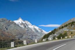
The journey to the LGKS went smoothly. We arrived at the small wooden hut in good time, showed our ticket, received the magnet we had bought in advance and only had to wait a short time – then we were off! The weather gods meant well: bright blue skies, sunshine, just a few spring clouds over the peaks. Soon we were over 2,000 meters high, the tree line was below us, the mountain was covered in white rock and short grass.
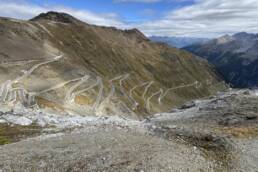
After a short drive, we suddenly found ourselves in front of a traffic light – it regulated a particularly narrow passage. The principle: from 08:30 there is 10 minutes green, then 50 minutes red. As we were very early, there was no oncoming traffic. Together with two other Suzukis and a few motorcyclists, we stood for almost 45 minutes. The cyclists ignored the signal. When it turned green, we let the motorcycles go ahead and then followed them through the impressive mountains. Panoramic views to die for – we were speechless. Today, it’s no longer about the military and border protection, but about protecting the sensitive natural environment – hence the mandatory ticketing and traffic light regulations.
The route was challenging, but doable. And suddenly a small Fiat Panda came towards us 😲 How does it do that? Do they carry it? Is there an elevator here? Can it fly? Wow!
After around an hour, we headed downhill again, close to the tree line. Something was wrong – at over 2,000 meters, hardly any trees should have been growing. We hoped that we would soon be heading back up to the fortresses. But no such luck. We continued downhill through the forest until we reached another wooden hut, which obviously marked the starting point for the opposite direction. Was that all? Had we lost our way?
Other off-roaders came towards us or overtook us, it got more crowded, but never really hectic. A Belgian biker asked if he was on the “salt road”. Yes, he was right – but were we? He hadn’t seen any fortresses. A quick look on Google showed that he was probably referring to the fort at the nearby Col de Tende. Large fortifications such as the Forte Centrale or the Forte Alto were built there in the 19th century to protect Italy against France. We had only caught them on our aerial photos at the very beginning.
And so it remained: the stretch through the mountain massif was impressive, but we’ll have to tackle the fortresses another time.
So we continued to follow the satnav and the track, over numerous hairpin bends up to the next pass. At the top, we met mountain bikers and gravel bikers. Regine offered to take a photo of them on the descent – greetings at this point, great effort from you!
Then the descent began – and that was to be taken literally 😳 Scree, thick rock steps, narrow hairpin bends, no end in sight. We preferred to clear the path a few times to protect the Vitaralino. A touchdown here could have ended badly. At some point, we managed that too – a few nerves down, but we arrived at the bottom in one piece.
The next junction made us wonder for a moment: normal road signs, the barrier was open, but there was no green sign. We continued to follow the navigation system – after all, we had learned in the Carpathians: never deviate from the track. The road got better, even pleasant in places. Unfortunately, clouds gathered and the view disappeared.
And then came the shock moment of the day: the power steering suddenly failed. Driving straight ahead was no longer possible, steering to the left was difficult, steering to the right required a great deal of effort. It was immediately clear to us that there could be many reasons for this – too little hydraulic fluid, a broken pump, perhaps just a stuck universal joint? One thing was certain: in the middle of the mountains, this was no place for major experiments.
After all the meters of altitude, dusty tracks and the concentrated history of the LGKS, we finally reached Ventimiglia – and with it the Mediterranean. 🌊
From our accommodation, we headed straight to the beach, listened to the waves and watched the last rays of sun on the horizon. A perfect transition: mountains behind us, sea in front of us. We ended the day in style with a really good Italian pizza – dolce vita after an off-road adventure. 🍕☀️
Conclusion: The LGKS was an impressive experience – a mixture of history, nature and off-road adventure. Even though we missed the fortresses this time, the route itself was a highlight in itself. It is particularly exciting that a former military border road now inspires hikers, cyclists and off-roaders alike – and that a symbol of demarcation has become a shared adventure space. But in the end, a technical problem overshadowed the euphoria: our trusty Vitaralino suddenly showed weaknesses in the steering. You’ll find out what was behind it – and whether it jeopardized our trip – tomorrow… 🚙⛰️